Great Northern Expedition. Bering-Chirikov detachment 1740-1742
In 1732, Vitus Bering was entrusted with leading the Second Kamchatka (Great Northern) Expedition. His tasks included not only coordinating the work of the entire expedition, but also direct leadership of one of its detachments. Alexey Chirikov was appointed Bering's assistant again, as in the First Kamchatka Expedition.
On May 2, 1732, the Senate issued a decree “On the departure of Captain-Commander Bering to Kamchatka and on the rules that he must observe on this expedition.” According to the decree, Bering's detachment had to cross Siberia and from Kamchatka head to North America to explore its coast and study the life and customs of the peoples inhabiting these lands. To sail to the American shores, Bering and Chirikov were tasked with building two special vessels.
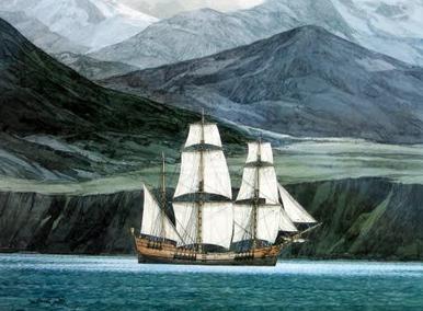
All the necessary equipment and food for the expedition was prepared by the summer of 1740. At the same time, in Okhotsk, under the leadership of shipwrights Kozmin and Rogachev, the construction of two ships was completed. In September 1740, the packet boats “St. Peter” under the command of Bering and “St. Paul” under the command of Chirikov left Okhotsk. During a storm off the coast of Kamchatka, some of the food was lost. In October, the expedition arrived in Avachinskaya Bay and stopped for the winter in the bay, which Bering called Petropavlovskaya. A fort was founded here, which later grew into the city of Petropavlovsk-Kamchatsky.
With the beginning of navigation, the expedition members began to prepare for departure. To resolve the issue of the ships' route, Bering convened a council of officers, navigators and scientists. The opinions of the council participants were divided: the commander proposed sailing to the northeast, Steller - to the east, astronomy professor Delacroer - to the southeast, where, in his opinion, the so-called land of Juan de Gama should be located. After discussion, it was decided to explore this land and then continue on to the shores of America.
On the morning of June 4, 1741, “St. Peter” and “St. Paul” left Peter and Paul Bay. Having reached 47° N. sh., where the mythical land was supposed to be located, the participants in the voyage came to the conclusion that it did not exist, and the time and effort of the expedition were wasted. The ships turned north. Navigation conditions were difficult, with storms and thick fog making it difficult. In order not to get lost in the fog, ships fired cannons or rang a bell. On June 19, neither shots nor bells helped - the ships were separated.
For three days, Bering and Chirikov tried in vain to find each other, after which Bering gave the order to move north, and Chirikov headed northeast. The fate of the expedition detachments turned out differently.
For about four weeks "St. Peter" continued sailing to western shores America. In the first half of July, vague outlines of land became visible along the ship's course - the ship was sailing along the Aleutian Islands. On July 16, 1741, the expedition members finally saw a coast with high mountain ranges covered with snow. This was the long-awaited America. Strong winds did not allow them to approach the shore; only on July 20 did the packet boat drop anchor near a small island.
For reconnaissance, a boat with 15 sailors was sent ashore, led by Sofron Khitrovo. Having stocked up on fresh water, the sailors returned to the ship. Later, Bering sent the naturalist Steller to the island, accompanied by the Cossack Lepekhin. Steller spent 10 hours on the shore, during which time he discovered and examined the dwellings of the Indians, compiled a description of about 160 species of local plants, as well as a description of some representatives of the fauna (seals, whales, sharks, sea beavers, foxes, several species of birds, including the crested jay that was later named after him (Steller's crested jay).
H Great Northern Expedition
two months after returning from the expedition, at the end of April 1730, V. Bering compiled two memos to the Admiralty Board (naval department); they were submitted to the Senate only at the end of that year. In the first “Proposal,” he, in particular, expressed confidence in the comparative proximity of America to the Kamchatka Peninsula and the advisability of establishing trade contacts with local residents; he noted the need and opportunity to develop iron ore in Siberia, sow grain and cook salt. In the second note, V. Bering put forward a plan to “find out the northern lands...,” that is, to establish how far to the north Asia extends and to map the northern coast of the continent. He also proposed to find out the possibility of reaching the mouth of the Amur River and the Japanese Islands by sea and, finally, to send ships to the shores of America. In other words, V. Bering put forward a plan for a new large expedition and expressed his readiness to take part in it.
Biographical index
Behring, Vitus Johansen
Russian navigator of Dutch origin, captain-commander, explorer of the northeastern coast of Asia, Kamchatka, the seas and lands of the northern part of the Pacific Ocean, the northwestern coast of America, leader of the 1st (1725–1730) and 2nd (1733 –1743) Kamchatka expeditions.
In 1733, the government put V. Bering at the head of the Second Kamchatka Expedition, appointing “another captain, a good one, from the Russians” - A. I. Chirikov - as his comrade. They had to cross Siberia and go from Kamchatka to explore the opposite shores North America(“search of the American coasts from Kamchatka”), and M. Shpanberg, having put the Kuril Islands on the map, sailed to Japan and established contact with it (“observation and exploration of the route to Japan”), Several detachments were supposed to map the northern shores of Russia from Pechora to the extreme northeast and, if possible, to Kamchatka (“to find news... whether there is a passage through the North Sea”), and the Academic detachment to explore the interior regions of Siberia. The expedition was supposed to be completed in six years. The overall command of the entire expedition, the largest in terms of the volume of tasks, the territory explored and the number of participants, was entrusted to V. Bering. But in fact, when he moved to Okhotsk, only two detachments were subordinate to him - his and M. Shpanberg's. Although the northern detachments worked independently, all their activities were controlled by V. Bering. This is confirmed not only by his reports to the Admiralty Board and his detailed report on the research they carried out, but, most importantly, by correspondence with the commanders of the detachments.
The Academy of Sciences seconded a group of scientists to the expedition, which is usually called the Academic detachment of the Great Northern Expedition.
At the beginning of 1734, the entire expedition led by V. Bering gathered in Tobolsk. From there, he sent several land parties of surveyors to study the ocean coast, adding two people from the retinue of professors to those already available, and headed to Yakutsk, where he reached at the end of October. V. Bering had to spend three years there: he organized the construction of an ironworks and a rope workshop, organized the collection of resin and the manufacture of rigging for ships, provided assistance to M. Shpanberg’s detachment, which was in a difficult situation, and ensured that equipment and food were sent to Okhotsk.
In the end, up to 800 members of various detachments accumulated in Yakutsk - officers, sometimes with wives and children, scientists, surveyors, craftsmen, sailors, soldiers and exiles for transporting goods. In response to V. Bering’s persistent requests for help, the inactive local authorities began to write denunciations to the capital and in every possible way interfere with the procurement of food and equipment. The St. Petersburg authorities “helped” in their own way: they deprived V. Bering of his extra salary. But he left Yakutsk only after making sure that the team was fully provided with provisions. In Okhotsk, where V. Bering moved, in three years he also had to overcome many difficulties and the open hostility of the commandant of Okhotsk.
The Admiralty Board reached the highest point of irritation: from the reports received by the board, only one thing was seen that “the forests are being harvested, and ships are being built, and sails are being sewn...”. And the authorities indicated that “the scaffolding should have been prepared long ago, and the ships should have been built, and the sails should have been sewn,” and demanded that V. Bering “set off on his journey without any delay, without bothering with correspondence, as if unnecessary, without any action.”
At the beginning of September 1740, V. Bering sailed from Okhotsk to Kamchatka. On the eastern coast of the peninsula, near Avachinskaya Bay, in the beautiful harbor discovered by his sailors, which he called Petropavlovskaya - after two ships of the expedition: “St. Peter" and "St. Pavel,” the expedition overwintered.
On June 4, 1741, eight years after leaving St. Petersburg, V. Bering and A. Chirikov reached the shores of America. Each of them commanded a ship with a displacement of about 200 tons and a crew of 75 people. On V. Bering's ship "St. Peter" was a young scientist Georg Wilhelm Steller, famous for his description of this voyage. V. Bering's assistant was a Swede Sven (Xavier) Lavrentievich Vaksel, who also left an interesting description of the expedition.
Bering first went to the southeast (towards 45° N) in search of the mythical “Land of Juan da Gama”. This large “land” was located on some maps of the 18th century, including the one available to V. Bering, approximately between 46–50° N. w. and 159–173° E. “...My blood boils in me every time,” notes S. Veksel, “when I remember the unscrupulous deception into which we were led by this incorrect card, as a result of which we risked our lives and good name. Through [her] fault... almost half of our team died in vain.” Having lost more than a week in vain and making sure that there was not even a piece of land in this part of the ocean, both ships headed to the northeast. On June 20, thick fog fell on the sea, and the ships were separated forever. Three days of St. Peter spent searching, walking a total of about 400 km to the south, and then moved alone to the northeast.
On July 17, 1741, at 58°14" N, the St. Peter finally reached the American coast and the crew saw in the distance the majestic snowy ridge of St. Elijah with the peak of the same name (Mount St. Elias, 5488 m, is one of highest points North America). Everyone congratulated V. Bering on the great discovery. But the sixty-year-old captain-commander did not show any signs of joy when he saw the shore to which Peter I first sent him 17 years ago. Moreover, as G. Steller reports, he looked gloomy and sad. He did not know exactly where he was and looked anxiously into the future; He felt bad - scurvy began. Not daring to come closer because of the weak, variable wind, V. Bering moved west along the coast, noted a glacier nearby that now bears his name, and three days later discovered a small island. Kayak at 60° N. w„and just to the north there is a small bay (Controller), formed by a narrow peninsula of the “hardened” coast. He sent a boat there for fresh water under the command of the master of the fleet (senior navigator) Sofron Fedorovich Khitrovo and released G. Steller ashore, although short term. He later complained that it took 10 years to prepare the expedition, and he was given only 10 hours for research, as if they came only “to take and transport American water from America to Asia.” Seriously ill, the captain-commander himself never went to the American shore. Without even filling all the barrels with water, V. Bering went west on July 21 in stormy, rainy, cloudy weather, drifting south, probably near Montagu Island (July 22) and Kodiak (July 26), since from “St. Peter" they saw the high banks in the fog. On the ship, a third of the crew was already sick with scurvy, and in addition, there was not enough fresh water.
On August 2, Fr. was opened. Tumanny (renamed at the end of the 18th century at the suggestion of George Vancouver in about. Chirikov), August 4 - Evdokeevsky Islands (otherwise, Semidi, near 56° N), off the coast of the Alaska Peninsula, where snowy mountains were seen. On August 10, when it was already three weeks of “St. Peter” maneuvered against a strong headwind and made little progress, and the scurvy was getting worse, V. Bering decided to go straight to Kamchatka.
On August 29, sailors discovered “treeless and deserted islands” off the southwestern tip of Alaska, on one of which two days later they buried the first victim of the expedition, a sailor Nikita Shumagina. There "St. Peter" stood for a week, and during this time the Russians met for the first time with the local "Americans" - the Aleuts, as they began to be called a few years later.
From the Shumagin Islands (the name was given by V. Bering) from September 6, they sailed all the time to the west in the open sea. Sometimes land appeared in the north, and the sailors mistook it for America, since mountains rose in the distance behind the islands - but in fact it was the Aleutian chain. On September 25 we saw “a considerable number of islands” (probably from the central, Andreyanov group), on October 25–29 - three islands from the western groups (Rat and Blizhny). The weather was very stormy almost all the time, the ship was carried along the waves “like a deck.” There was not enough water and provisions. Finally, on November 4, they appeared in the distance high mountains, covered with snow. The sailors decided that they had approached Kamchatka, and, not finding a convenient harbor, they anchored at some distance from the shore, near the rocks. The anchor ropes broke twice. Suddenly high wave threw the ship over the breakers into the bay, which was relatively calm and quite deep. This was exceptional luck after so many misfortunes; people hastened to move to land.
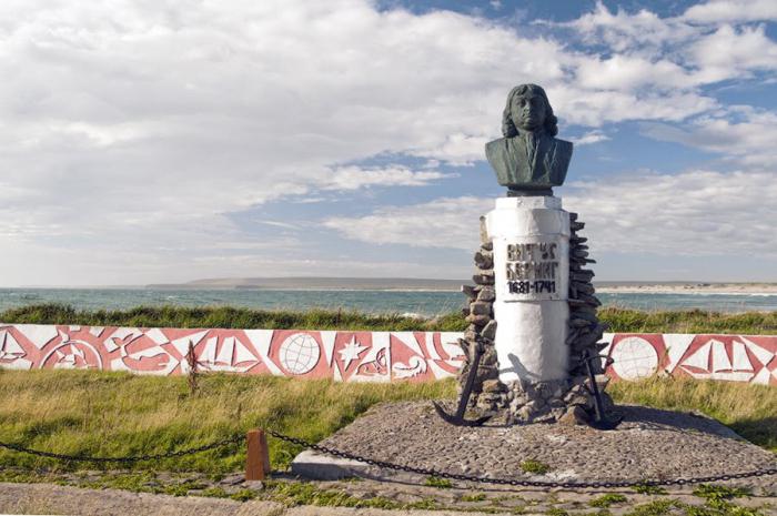
On the shore, they dug six rectangular holes in the sand for housing and covered them with sails. In the summer of 1981, the Soviet complex expedition "Bering-81" carried out archaeological work on the island. Bering, excavated dugouts and discovered many objects, as well as seven cannons from “St. Petra." When the transportation of the sick and supplies to the shore ended, only 10 sailors were still standing. 20 people died; the rest suffered from scurvy. The sick V. Bering lay in a dugout for a whole month, half-buried with sand, believing that it was warmer. On December 6, 1741 he died. The land to which his ship washed up later received his name - Fr. Bering, and the entire group was christened the Commander Islands, in honor of the deceased captain-commander. The sea discovered by F. Popov and S. Dezhnev, along which V. Bering sailed so little in 1728, was called the Bering Strait, the strait through which he was not the first to pass, but the same F. Popov and S. Dezhnev, marked on map not by them, but by M. Gvozdev and I. Fedorov, was named the Bering Strait at the suggestion of D. Cook. To the unfortunate captain-commander Vitus Bering, as 130 years before him to another unlucky man, Henry Hudson, came exceptional posthumous fame.
After the death of V. Bering, Sven Waxel took over the command as a senior officer, but all issues were resolved at general meetings. (He took his son with him on the voyage Lorenz - Lavrentiy Ksaverevich Vaksel, a ten-year-old boy who successfully passed all the tests. Subsequently, L. Vaksel became an officer in the Russian fleet). In winter, sailors walked around new land and made sure that they were on the island. In the west, they found Kamchatka forest washed ashore, fragments of boats, sleighs, etc. In the middle of winter, 10 more people died. The 45 survivors survived until the summer of 1742, overcoming numerous difficulties and hardships. The winter was difficult: stormy winds often blew, often reaching hurricane force, twice from earthquakes Records of S. Vaksel about earthquakes on the island. Bering turned out to be the first information about the seismicity of the islands of the northern part Pacific Ocean. the sand almost completely covered the dugouts. True, there was no shortage of fuel - the waves washed a lot of timber ashore, but they had to carry it on their shoulders for 10 miles. There were many arctic foxes on the island. The so-called Kamchatka beavers (sea otters) and huge but harmless mammals - sea cows, now extinct, swam off the shores of the sea that did not freeze in winter; In the spring, countless herds of seals appeared. And the crew engaged in very easy hunting on this island, which provided enough meat, since the beast here had never seen a person before and therefore was not afraid of him. Each winterer also received bread: 250–400 grams of flour were issued daily from the saved supplies.
The dilapidated ship "St. Peter" was dismantled. From its parts in May 1742 they began to build a new, small ship (gukor), also called “St. Peter." Among the officers and navigators there was no specialist shipbuilder, and all three ship carpenters died of scurvy. Krasnoyarsk Cossack Savva Starodubtsev, who was a simple worker during the construction of expedition ships in Okhotsk, took up the matter and successfully completed it, leading a brigade of 20 sailors. S. Vaksel wrote that he “would hardly have been able to cope with the matter without his [Starodubtsev’s] help.” (According to the proposal of S. Vaksel, S. Starodubtsev was awarded the title of son of a boyar in 1744.)
S. Vaksel, S. Starodubtsev was awarded the title of son of a boyar in 1744.) On August 9, the ship was launched. Its length (along the keel) was 11 m, and its width was 3.7 m. It accommodated 46 people, of course, in terrible cramped conditions. They went to sea on August 13, saw four days later Kronotsky Cape (54°45" N), but did not dare to land there and went to Petropavlovsk (53° N), and due to calm or contrary winds they were forced were for the most part rowed and only reached Petropavlovsk on August 26, 1742.
Chirikov's navigation - the discovery of North-West America and the Aleutian Islands Having lost sight of V. Bering's ship on June 20, A. Chirikov on the "St. Pavle" went east. On the night of July 15-16, i.e. a day and a half earlier than the captain-commander, he saw the first American land, mountains and forest descending to the sea (Prince of Wales Island or one of nearby islands at 134° W). In search of a convenient harbor, he turned to the northwest and three days later, having walked about 400 km along the islands that make up the Alexander Archipelago, he found a suitable place. On the shore (it was Chichagov Island or its imaginary protrusion - Jacobi Island, at 58 ° N) 11 armed people went on reconnaissance, and after a week of fruitless waiting - four more. All of them went missing. The loss of 15 people and two boats, without which it is impossible to replenish supplies fresh water, put the expedition in a difficult situation, and on July 25 L. Chirikov decided to return to Kamchatka.
He moved a little more to the northwest and saw the mountain range (St. Elijah), and then turned west, out to sea. At the Kenai Peninsula he discovered on August 1, he set off on a southwestern course. Until August 3, the sailors saw high ground, - undoubtedly, Fr. Kodiak. Due to calm and fog, the ship took ten weeks to sail from here to Petropavlovsk. On the way, some Aleutian islands were discovered, most likely: on September 5, Umnak, from the Fox group, closest to the Alaska Peninsula; September 10 - Adah, from the central group (here the sailors from the St. Paul first met the Aleuts); September 22 - Agattu and Attu, from the Neighbors group. October 10, 1741 “St. Pavel" returned to Peter and Paul Harbor. Six people died of scurvy along the way.
In May–June 1742, A. Chirikov repeated on “St. Pavle" sailing east from Kamchatka, but only reached about. Attu turned back because of the fogs and nasty winds. On the way back on June 22–23, he saw Fr. Bering, where people from “St. Peter,” and discovered Fr. to the southeast of him. Copper. Came "St. Pavel" in Petropavlovsk on July 1. A. Chirikov asked the Admiralty Board to recall him from Siberia, but this was done only in 1746. And two years later he died in St. Petersburg (November 1748).
For the detachment of M. Shpanberg in Okhotsk, two ships were built and a third was repaired. One ship was commanded by M. Shpanberg himself, the other by a native of England, Vilim Valton, third - Alexey Elizarovich Shelting. At the end of June 1738, the flotilla moved from Okhotsk to Bolsheretsk, and on July 15 headed south from there. Four days later, A. Shelting fell behind in thick fog (the next day he turned back); five days later V. Valton also fell behind; M. Shpanberg alone continued his journey along the Kuril ridge. Bypassing it, he reached the Frieza Strait and went around the island. Urup, mistaking it for a group of islands. M. Shpanberg was afraid to go further to Japan alone, and on August 17 he returned to Bolsheretsk (later he referred to a lack of provisions).
V. Walton, having separated from M. Shpanberg, reached the eastern ledge of Hokkaido (Nemuro Peninsula, 43 ° 20 "N), mapped 26 islands and on August 27 returned to the mouth of the Bolshoi River. During the winter in Bolsheretsk The sailors built an eighteen-oar sloop from birch. On May 21, 1739, four ships of M. Shpanberg’s detachment left the mouth of the Bolshaya River. From Makanrushi Island (one of the northern Kuril Islands, near 50° N, 154° E. d.) they moved straight south to 42° N in search of the “Land of Joao da Gama”. Not finding it, M. Shpanberg headed southwest. At latitude 39° 30 "V. Walton again behind. The remaining three ships on June 16 at 39° N. w. approached Fr. Honshu and traveled south along its eastern shore for six days. Apparently, they stopped in the area of Sendai Bay (between 38 and 38 ° 15 "N). The Japanese, according to their reports, saw two or three unknown ships there on June 17–21, 1739. Residents met the Russians far away, not hostile. But M. Shpanberg did not dare to go ashore, did not even stock up on fresh provisions, although he had scurvy patients on board, and weighed anchor on June 23. On the way back, he rounded the southern Kuril Islands and approached the island. Hokkaido, but did not land on the shore.So M. Shpanberg returned to Kamchatka without establishing relations with the Japanese, i.e., without completing the task.
V. Walton distinguished himself this time too: he walked to the southeastern ledge of Honshu and sent eight people ashore for water. The Japanese helped them get water. From there, V. Walton sailed south, past some flowering shores, and at 33°28" N latitude he dropped anchor off a small island (probably from the Izushitito group), where he stayed for a day. In July he returned to the Sea of Okhotsk.
In the autumn of 1741 A. Shelting together with the surveyor M. Gvozdev on a double boat A dubel-boat is a military sailing-rowing vessel that had two masts and was armed with several small-caliber cannons.“Nadezhda” traced the western coast of the Sea of Okhotsk to the mouth of the Uda, and then examined the Shantar Islands in search of a convenient anchorage. In August 1742, A. Shelting, exploring southern part Sea of Okhotsk, approached at 50 ° 10 "N latitude to the eastern coast of Sakhalin, which he accepted according to Frieze's map as Yesso Land. He first descended south to the latitude of the La Perouse Strait and, like Frieze, did not notice it in the fog. From here " Nadezhda "moved east, in a vain search for at least a piece of land, traveled 2000 km and turned back. On the way to Okhotsk (where the ship arrived on September 10), A. Shelting followed the entire eastern (more than 600 km) coast of Sakhalin, then completely unknown Again, fogs prevented the sailors from seeing the coast, so the photography done by M. Gvozdev was unsatisfactory.
M. Shpanberg turned out to be a bad leader of the research expedition; over the years he showed “excessive caution” bordering on cowardice, suspicion, grumpiness and envy of more successful officers. And yet, his detachment achieved major geographical results: the route from Kamchatka to Japan was opened; the entire “garland” of the Kuril Islands from Kamchatka Nos to Hokkaido, the western sections of the coast of the Sea of Okhotsk, including the eastern coast of Sakhalin (shown, by the way, as an island, and not as a peninsula) is mapped, although it is not very accurate, and in some places incorrect Asia) and part of Northern Japan; it has been proven that no land exists east of the Japanese Islands. These achievements were already used in the compilation of the eastern part of the “General Map of the Russian Empire”, published by the Academy of Sciences in 1745.
private member of the Great Northern Expedition midshipman Vasily Andreevich Khmetevsky in 1743–1744 completed the first detailed description parts of the northern shore of the Sea of Okhotsk. Together with an assistant Andrey Shaganov he began surveying on June 28, 1743 from Okhotsk. In almost two months, “without a proronku,” i.e., passes, they passed on the bot, Boat is a single-mast sailing and rowing vessel. following all major bends to the mouth of the river. Fogs flowing into Gizhiginskaya Bay (at 156° E). On August 25, due to contrary winds, it was necessary to suspend work and drop anchor, and the next day a storm broke out, causing significant damage to the ship. Only on September 2 was it possible to continue filming to the mouth of the river. Viligi (at 157° E). Lack of provisions and strong winds forced V. Khmetevsky to complete the inventory. The boat moved to the southeast, crossed Shelikhov Bay and, after a four-day journey, touched the coast of the Kamchatka Peninsula near 59° N. w. But none of the sailors could say where they were. V. Khmetevsky moved along the coast to the southwest and only on September 12, having traveled more than 400 km to the mouth of the river. Cloudberry has finally made up his mind.
The ship settled for the winter a little to the north - at the mouth of the river. Khairyuzova (at 57° N latitude). In winter, V. Khmetevsky compiled a map of the filmed part of the northern coast (more than 1500 km). In the summer of 1744 he and the surveyor Mikhail Vasilievich Nevodchikov, a participant in M. Shpanberg's voyage to Japan, sent in place of the deceased A. Shaganov, surveyed the coast of Kamchatka from the wintering point to Bolsheretsk (600 km.).
V. Khmetevsky managed to complete the study of the remaining undescribed Gizhiginskaya and Penzhinskaya lips only after 18 years: in the fall of 1753, while commanding a packet boat, he crashed off one of the Kuril Islands and was under investigation until 1761. In two “meals” with rest on the river. Tigil (March 17 - April 5 and June 10 - July 20, 1761), on the brigantine he and his assistant Ivan Andreevich Balakirev filmed about 2 thousand km of the coast, the total length of the survey reached 4.1 thousand km. The map compiled by V. Khmetevsky, of course, differed from our contemporary maps, but still quite accurately conveyed the configuration of the northern, most rugged, part of the Sea of Okhotsk - the Gizhiginskaya and Penzhinskaya lips. It reveals relatively regular contours of the Taui Bay, the Kony and Pyagin Peninsulas, These peninsulas received names only in the second half of the 19th century. as well as Yamskaya Bay.
back in 1734, V. Bering instructed two surveyors - P. N. Skobeltsyn And V. Shetilov, who worked for several years in Transbaikalia, to find a shorter route than the Yakut one to the Sea of Okhotsk. It also had to meet another requirement - not to pass along the river. Cupid. The surveyors chose Nerchinsk as the starting point for the journey.
An attempt to find guides in 1734 failed: local residents who lived in the taiga did not use the dry route, preferring to move by water. They chose some left tributary of the river. Shilki climbed along it to the upper reaches, and then returned along the same road.
In the summer of the following year, at the head of a party that included several Cossacks and translators, with guides who assured that they knew how to get to the river. Udu, P. Skobeltsyn and V. Shetilov floated down the river. Shilke to the mouth of the river. Gorbitsy, its small left tributary (at 119° E). Here they mounted horses and slowly moved east through the mountain larch taiga, bypassing the swamps and crossing the upper reaches of numerous tributaries of the Shilka and upper Amur.
After a hard winter somewhere in the upper reaches of the river. The Bolshoi Oldoy, a tributary of the upper Amur (at 123° E), surveyors decided to complete the work. They crossed to the upper reaches of the river. Nyukzhi and filming went down it and along the river. Olekme on the river Lena. They arrived in Yakutsk at the beginning of June 1736 and presented maps of most of the river's course. Nyukzha and lower Olekma.
By order of V. Bering, surveyors had to repeat the search for a road on the river. Udu. Through Irkutsk they arrived in Nerchinsk and at the beginning of June 1737, at the head of a larger detachment, they again headed east. This time they managed to reach the upper Gilyuy. They followed the November snow on sleds and skis to its confluence with the river. Zeya and, undoubtedly, saw the Tukuringra ridge accompanying the right bank of the river. For a whole month the detachment climbed the Zeya until food supplies ran out. In addition, the guides could not indicate the roads to the river. Udu. I had to turn back. Through ridges and hills in the northwestern part of the Amur-Zeya plateau, surveyors reached the river. Amur at 124° E. and returned to Nerchinsk at the end of December.
P. Skobeltsyn and V. Shetilov did not carry out the order of V. Bering, but the first crossed in the latitudinal direction the Amur taiga and the “stone placers” of the southern slopes of the mountains, which, as we now know, are part of the Olekminsky Stanovik and Stanovoy Range systems. According to their calculations, the length of the route through this completely unexplored and deserted area, taking into account wanderings due to the lack of good guides, was 1,400 km.
The task posed by V. Bering was solved only after 114 years: from r. Gorbitsy to the river A topographer passed Udy in 1851 V. E. Karlikov.
Web design © Andrey Ansimov, 2008 - 2014
It is known from school textbooks that in 1725, by order of Peter I, the expedition of Vitus Bering set off from St. Petersburg towards Kamchatka. Its stated task was to clarify the data geographical maps and testing the existence of a strait between Asia and North America. However, according to modern historians, the true purpose of the voyage was completely different.
Springboard for attack on America
According to archival historical documents, the sea voyage was organized to study the possibility of seizing the lands of North America by the Russian crown. In this case, the support base Russian troops Kamchatka was to become, to the shores of which Bering was sent. Nevertheless, the official task of the expedition also had to be completed. When the ships reached the coast of the peninsula, Bering was faced with the question of what to do next. It was possible to continue sailing and, with full equipment, go around Kamchatka, reaching the strait separating Eurasia and North America. But there was a second option. To once again do not expose officers and soldiers to the risk of sailing in choppy waters northern seas, and also to let them feel the solid ground under their feet, Bering invited the military members of the expedition to cross Kamchatka on foot. Then the ships would pick them up on the other side of the peninsula. In parallel, soldiers and officers had to scout out the most comfortable places for the construction of fortresses if Russia begins military expansion into North America.
The second option was recognized as the best, and the bulk of the people came ashore. But carrying equipment and weapons was not an easy task. We decided to involve local residents - Kamchadals from the Itelmen tribe. They had been conquered by the Cossacks for thirty years and were perfect for the role of porters. But how to get them to help for free was a big question.
The fact is that the natives carefully paid taxes to the royal treasury in the form of animal skins. The sale of skins from Russia to Europe was extremely profitable, so nothing more was required from the Itelmens. However, they did not like the supremacy of white people. And then Bering suddenly fell out of the blue and wanted his team to be escorted free of charge, in the interests of the Tsar, across the entire peninsula. Plus, all this happened at the height of the hunting season, and the Itelmens were afraid that if they missed time, they would have nothing to pay the tax with, and this would lead to punitive measures from the local Cossacks.
First Kamchatka War
The cunning Dane Bering solved the problem by deception. He promised those who would help transport people and goods an exemption from the royal tax on skins for three years! How can I resist here? The Aborigines agreed. They had no idea that Bering, not having such powers, simply lied to them. When the scam was revealed, the navigator’s ships were already far away.
However, the Itelmens could not tolerate meanness and went to war against the tsarist administration, represented by the Cossacks. These events are preserved in history under the name “The First Kamchatka War.” First, the Cossack forts were captured. Then at night the Itelmens massacred the entire garrison of the Nizhnekamchatsk fortress, the main Russian fortification in Kamchatka. Only three Cossacks managed to escape and raised the alarm; however, at that moment it was too late. The peninsula returned to the rule of local tribes.
At that moment, ironically, one of Bering’s ships, the brig Gabriel, with soldiers and officers on board, was returning to St. Petersburg from North America. Armed sailors, having learned about the Kamchadal uprising, removed the ship's guns, went ashore and, besieging Nizhnekamchatsk, took it two days later. The rebellion was suppressed. The war between the surviving Cossacks and sailors and the local tribes became particularly fierce. Both sides fought extremely brutally and took no prisoners. The Cossacks won, and by 1732 they had completely captured Kamchatka for the second time.
The birth of the future navigator was not marked by any important events. No one imagined that the child would become not just a sailor, but a great discoverer, and even in the service of another state. It is difficult to say what reasons prompted the boy to enter the naval service in Russian Empire: Our power was not so powerful at that time. Perhaps Bering was able to see certain prospects for himself. Which to some extent contributed to the discoveries he made, which were practical, geographical, and historical meaning. Bering not only discovered new lands and islands in the north of the country, but also compiled maps of the coast, which was extremely important.
First years of life
Vitus Bering was born on August 12, 1681 in Jutland (modern Denmark) in the city of Horsens. The town was nothing special: several churches and monasteries - that’s all the attractions. It began to develop only after 1442, when it was issued a trade charter, and gradually turned into a commercial center.
The city was located on the seashore and had a port. From the first years of his life, the hero of our story admired the waves and dreamed of travel. Although his father was, according to some historians, a customs officer, and never left his native place. It is not very clear for what reason, but at the very beginning of his sailor career, the teenager took his mother’s surname.
The sea beckoned the boy, so it is not surprising that, having reached adolescence, he entered the naval cadet corps in Amsterdam, and in 1703, at the age of 22, he successfully graduated from it. But before that, Vitus Bering made a short trip to the East Indies on a Dutch ship. Apparently, after this, the future traveler Bering made a firm decision to connect his fate with the sea.

In the service of Peter I
How did Vitus Bering get into the Russian fleet? His biography does not contain accurate information on this matter. It is only known that at that time, by order of the Russian sovereign Peter the Great, Admiral of the Russian Fleet Cornelius Ivanovich Kruys was recruiting experienced sailors for service. Sievers and Senyavin introduced the boy, stating that he had already visited the East Indies, therefore, he still had some experience. From other sources it is known that Vitus wanted to serve, like his cousin Sivers, specifically in the navy, and certainly in the Russian Empire. Be that as it may, his dream came true, and Bering went to St. Petersburg. There he was assigned to manage a ship that transported timber for the construction of the Kronstadt fortress. Not God knows what, but still the sea!
Soon Vitus Bering received the rank of lieutenant and began to carry out more responsible and complex assignments. He took part in the Azov campaign, monitored the movement of Swedish ships in the Gulf of Finland, participated in the campaign from Arkhangelsk to Kronstadt, and served on the ship "Pearl" when ferrying it from Hamburg to St. Petersburg. And suddenly, without reaching the rank of captain of the first rank, Bering left military service.
Vitus Bering's track record
If compiled in chronological order all the ranks and titles that the navigator Bering received during his military career, we get the following table:
Entering the military naval service of the Russian fleet |
|
Received the rank of lieutenant (the modern rank of lieutenant) |
|
Vitus Bering transferred to serve in the troops on the Sea of Azov Awarded the rank of captain-lieutenant Entrusted with the command of the nasty "Munker" |
|
Service in the Azov Fleet, participation in the war with Turkey |
|
Transfer to service in the Baltic Fleet |
|
Vyborg, marriage to Anna Kristina |
|
Received the rank of captain 4th rank |
|
Bering takes command of the ship Pearl, which he must deliver from Hamburg to Russia |
|
Rank of captain 3rd rank |
|
Receives command of the ship "Selafail" |
|
The future navigator receives the rank of captain 2nd rank The ship Malburg was transferred to command |
|
Vitus Bering resigns with the rank of captain 2nd rank |
These are the titles and honors Vitus Bering received during his 20 years of service. short biography, however, does not reveal all the merits of the navigator. For historians and geographers, the subsequent part of his life is more interesting.
Development and annexation of Kamchatka to the Russian Empire
The ever-increasing oppression of serfdom could not but affect the history of Russia. Escaped peasants were looking for lands that would serve them as a refuge from persecution. So gradually people reached Siberia, and then Kamchatka. But the territory was already populated, so campaigns were organized to seize and develop lands rich in furs, etc. In 1598 it was defeated, and the territory became part of the Russian Empire.
The need to study Kamchatka

The development of Kamchatka and other Siberian lands was a matter of national importance. First of all, it was necessary to replenish the treasury. But the pioneers were mostly poorly educated people who primarily looked for minerals, discovered new territories and taxed the local population. The state needed maps of new lands, as well as a sea route.
In 1724, Peter the Great issued a decree on organizing a campaign against Kamchatka, headed by Vitus Bering. The traveler was ordered to get to Kamchatka, build two ships and go to the North on them, find the place where America connects with Siberia, and find a way from there to the cities of Europe.
The first Kamchatka expedition of Vitus Bering
Having received the position of leader and title, the future traveler began to carry out the order of the sovereign. After 2 weeks - January 25, 1725 - the first members of the expedition set off from St. Petersburg to Kamchatka. The group included two more naval officers (Alexey Chirikov and Martyn Shpanberg), surveyors, shipbuilders, navigators, rowers, sailors, and cooks. Total number reached 100 people.
The road turned out to be difficult and difficult. Had to get there different ways: carts, sleighs with dogs, river boats. Arriving in Okhotsk in 1727, they began building ships to carry out the main tasks of the expedition. Vitus Bering used these ships to reach West Coast Kamchatka. The warship “St. Gabriel” was rebuilt in Nizhnekamchatsk, on which the navigator and his crew set off further. The ship passed through the strait between Alaska and Chukotka, but due to weather conditions the sailors were unable to see the shores of the American continent.
The goals of the expedition were partially achieved. However, returning in 1730, he submits a report on the work done and draws up a project for the next expedition. Most of the top officials of the state and academicians did not understand, like Vitus Bering himself, what he had discovered. But the main thing has been proven - Asia and America are not connected. And the traveler received the rank of captain-commander.
Second expedition to Kamchatka
After the navigator returned, his words, notes and maps were treated with a certain distrust. He had to defend his honor and justify the highest trust placed in him. And the goals have not all been achieved yet. You can't stop halfway. So, a second expedition is appointed, and Vitus Bering commands it. A biography written by the traveler’s contemporaries claims that, shortly before the first trip to the shores of Kamchatka, a certain Shestakov discovered both the strait and even the Kuril Islands. But all these discoveries were not documented. The Dane was lucky - he was educated, knew how to structure and analyze the results obtained, and was good at making maps.
The second expedition of Vitus Bering had the following goals: exploring the sea from Kamchatka to Japan and the mouth of the Amur, mapping the entire northern coast of Siberia, reaching the American coast and trading with the natives, if any were found there.
Despite the fact that Anna Ioannovna sat on the imperial throne, Russia still remained faithful to Peter’s covenants. Therefore, influential officials from the Admiralty became interested in the project. The decree on the campaign was issued in 1732. Having reached Okhotsk, in 1740 Bering built two packet boats - “St. Peter” and “St. Paul”. On them, researchers reached the eastern coast of Kamchatka.

Expedition results
This time it was more successful. But at the same time tragic - during the winter in 1741, Vitus Bering died. What he discovered could only be appreciated later. After all, at that time it was difficult to verify the reliability of the results of his works - the road to Siberia was still too dependent on the vagaries of nature. But even then, travelers had already begun to use the maps compiled by Vitus Bering. The discoveries of the great pioneer made it possible to begin the development and exploitation of new lands.
So, the following was done:
- Petropavlovsk was founded in Achinsk Bay.
- The coast of Alaska was reached through the modern Bering Sea.
- On the way back, the Aleutian and Shumagin Islands are discovered.
- The Aleutian Range is mapped.
- The Evdokeevsky Islands and Chirikov Island (Tumanny) were discovered and mapped.
- Bering Island was discovered, on which the navigator died in 1741.
- The territories of the northern and eastern Russia, inland territories of Siberia.
- The Kuril Islands have been mapped.
- The way to Japan has been found.
If you carefully study history geographical discoveries, then we can find that this expedition was only part of a larger campaign. It was completed only a few years later after Bering's death, and even then only thanks to his organizational talent. After all, it was he who divided the participants of the Northern Expedition into groups, giving each specific tasks. Despite the human losses, the campaign was completed very successfully.
What did Vitus Bering look like?
Some biographers have doubts about the discoverer's appearance. It turns out that the familiar pictures depicting Vitus Bering (there were no photographs then) do not correspond to reality. These are portraits of his uncle. The controversy was resolved by examining the skull and recreating the appearance using modeling. As a result, the real face of the traveler was obtained. Indeed, Vitus Bering (photos presented in the article) had a completely different appearance. But this does not in any way detract from the importance of his discoveries.

The character of the great navigator
According to available information, the navigator had a somewhat soft character, which was not at all suitable for the head of the expedition. And yet Bering is appointed to this position twice. One more oddity should be noted. The explorer of Siberia did not like to bring matters to an end final result- he could stop at the moment when the goal was just a stone's throw away. This feature of Bering was noted by both friends and hikers. And yet, it was he who was recommended as a leader and organizer to both Peter the Great and Anna Ioannovna. How can this be explained? It must be that, despite all his shortcomings, Vitus Bering was an experienced navigator. He knew how to carry out orders, was very responsible and efficient, and, no less important, devoted to the state in whose service he was. Yes, most likely, it was precisely for these qualities that he was chosen to carry out such important geographical research.
Kamchatka explorer's grave

After Vitus Bering met his death on the island that he had discovered, he was buried and, according to the traditions of that time, a wooden cross was erected. It is clear that over time the tree decayed and crumbled. However, in 1864, at the place where, according to the records of Bering’s associates, his grave was located, a new wooden cross was installed. This was the merit of the Russian-American company founded under Emperor Paul.
In 1991 it was organized search expedition to the burial places of the explorer of Siberia. The grave of not only Bering, but also five other sailors was discovered on the island. The remains were recovered and sent to Moscow for research. The bones and skull were reconstructed appearance traveler Scientists were also able to find out that he died not from scurvy, as previously assumed, but from another disease (which one is not known for certain). After completing the research, the remains were returned to the island and reburied.
Objects that bear the name of the great navigator
In memory of the traveler and his contribution to geographical research, the following objects are named after him:
- Streets in Moscow, St. Petersburg, Astrakhan, Nizhny Novgorod, Murmansk, Petropavlovsk-Kamchatsky, Tomsk, Yakutsk.
- Island, strait, cape, glacier, sea.
- Icebreaker and diesel-electric ship.
- State University in Kamchatka.
- Plants that grow in the Far East.
In addition, the film “The Ballad of Bering and His Friends” was shot about the traveler.
The significance of the navigator's discoveries
It is impossible not to recognize the importance sea voyages Vitus Bering. It was thanks to him that the first well-drawn maps of Siberia appeared. Subsequently, this greatly helped the development of the Asian part of the Russian Empire. Thanks to his expeditions, active development of the region began. Minerals began to be extracted, and the mining and foundry industries began to develop.
The Russian Empire received an influx of money into the treasury and new territories, and its global importance and influence increased. And most importantly, the country got the opportunity to trade with those countries that were impossible to reach by already mastered routes. After all, these territories were under the jurisdiction of other states, which charged considerable fees for crossing them. However, despite all his merits, Vitus Bering received recognition posthumously, only after confirmation of his discoveries by other travelers. So, the now well-known one got its name from light hand James Cook.
Look at the map and find the Bering Strait, into which Cape Dezhnev protrudes far away. We already know why it is named that way. The brave Cossack was the first to cross the strait between Asia and America and settled on the Anadyr River, but later his discovery was forgotten.
At the beginning of the 18th century, after the difficult Northern War, Russia gained access to the Baltic Sea. Having opened a “window to Europe,” the Russians again turned their attention to the East.
The cradle of our Pacific Fleet and the main base of Russian expeditions was Okhotsk, founded in 1647 by a detachment of the Cossack Semyon Shelkovnik on the shores of the Sea of Okhotsk. Here, nearby, a “rafting site” was founded - a shipyard. The first naval ships were built like this. The bottom was hollowed out of the tree trunk, the sailors sewed bent boards to the bottom, fastening them with wooden nails or tightening them with spruce roots, the grooves were caulked with moss and filled with hot resin. The anchors were also made of wood, and stones were tied to them for weight. Such boats could only be sailed close to the shore. It was dangerous to go far out to sea on them. In addition to the shitiks, kochis were also built.
But already at the beginning of the 18th century, craftsmen-shipbuilders, originally from Pomorie, came to Okhotsk. And so in 1716, having built a lodia - a large sailing sea vessel, a detachment under the command of the Pentecostal Cossack Kuzma Sokolov and the sailor Nikifor Treski laid a sea route from Okhotsk to Kamchatka. Soon, ship voyages on the Sea of Okhotsk became common, and sailors were already attracted by the vastness of other seas.
The most significant of all Russian Pacific expeditions were the first half of the XVIII centuries were Kamchatka expeditions Bering - Chirikov.  Dutchman Vitus Bering, an experienced sailor who entered Russian service in 1703, participated in Northern War, has been in sea battles and long voyages more than once. Peter I instructed him to establish whether Asia converges with America and how far European possessions in the New World are from the Russian shores. Bering's assistants were a young Russian sailor, Alexei Ilyich Chirikov, and a native of Denmark, Martin Petrovich Shpanberg.
And at the beginning of 1725, the expedition set off from St. Petersburg on a difficult and long journey. Only two years later her last detachment reached Okhotsk. From Okhotsk to Bolsheretsk, sailors sailed on the Vostok boat and the Fortuna boat, and from Bolsheretsk to Nizhne-Kamchatsk they transferred cargo on sleds.
Here, in Nnzhne-Kamchatsk, the boat “St. Gabriel”, on which the expedition went to sea on July 14 (25), 1728. Heading north, the boat rose above Cape Dezhnev, and then turned back, never reaching the coast of North America. This honor fell to the lot of surveyor Mikhail Gvozdev and navigator Ivan Fedorov, in 1732 on the same boat “St. Gabriel" sailing in the Bering Strait. However, reports from their authorities do not gave meanings.
In 1733, Bering led a new Russian expedition to the Pacific Ocean. This time, in addition to sailors, it included scientists and students of the Academy of Sciences, this expedition is called differently - the Second Kamchatka, and the Siberian-Pacific, and the Great Northern, because the range of tasks that it had to solve included an inventory of the coast Northern Arctic Ocean, and the search for routes to North America and the shores of Japan.
The sailors, who set out on a long voyage with Vitus Bering in June 1741, visited the coast of Alaska and discovered many unknown islands in this part of the Pacific Ocean. However, on the way back, their ship “St. Peter" was washed up by waves on an uninhabited island, later named after the leader of the expedition. The winter was difficult. Many sailors, including Vitus Bering, died from scurvy and other diseases. The survivors built a small ship from the wreckage of the broken ship and returned to Kamchatka on it in the summer of 1742.

The second ship, "St. Pavel,” under the command of Alexei Ilyich Chirikov, reached the shores of North America safely, although at the very beginning of the voyage he missed the “St. Peter." Chirikov rejoiced: his dream came true!
The sailors mapped the islands they discovered and the northwestern coast of America for four hundred kilometers and established that these places were completely unknown to European sailors. Upon returning to Petropavlovsk, they experienced enormous hardships and difficulties, many of them died from scurvy and exhaustion. paved the way to previously unknown shores, and soon, in 1743, mass voyages of Russian industrialists to the Commander and Aleutian Islands began. Russians began sailing to the Kuril Islands even earlier - at the very beginning of the 18th century.
