Any modern man knows that there are six continents on Earth, this number includes North America, South America and Australia. They relate to such a historical phenomenon as the Great geographical discoveries. In this article we will briefly look at them!
Nowadays, it is difficult to imagine life without such wonderful places as New Zealand and the Hawaiian Islands. Now almost anyone has the opportunity to visit these parts of the planet for relatively little money. Has this always been the case? Of course not. There was a time when people did not even know about the existence of these places.
Periodization of the Great Geographical Discoveries
If we talk about defining the period of the Great Geographical Discoveries, they occurred at the end of the 15th – mid-17th centuries. Let's see why these discoveries are called “Great”. This name is due to the fact that they had special significance for the destinies of our world in general, and Europe in particular.
Great geographical discoveries were made at their own peril and risk, because travelers did not know what exactly awaited them. The only thing they clearly understood was the importance of their wanderings. There were enough reasons. Let's take a closer look at some of them.
The Age of Discovery is divided into two periods:
- Spanish-Portuguese period (late 15th – mid-16th century) The most famous and, of course, the most important discoveries during this period were: the discovery of America (the first expedition of Christopher Columbus in 1492); discovery of the sea route to India by Vasco da Gamma (1497–1498); F. Magellan's first circumnavigation of the world (1519–1522).
- The period of Russian and Dutch discoveries (mid-16th – mid-17th centuries). It usually includes: The discovery by Russians of all of Northern Asia (from Ermak’s campaign to the voyage of Popov-Dezhnev in 1648), the Dutch Pacific expeditions and the discovery of Australia.
Origins of the Great Geographical Discoveries
There were only three main reasons for the Great Geographical Discoveries. Firstly, they were due economic development Europe. Towards the end of the 15th century. European trade with the countries of the East was experiencing a great crisis. The crisis was due to the fact that a new harsh state appeared in the vast expanses of Asia Minor - the Ottoman Empire.

Therefore, the trade routes of the Mediterranean were completely cut off, because previously they passed through the disappeared Byzantium. In the 15th century In the countries of Western Europe, people needed gold and silver as a means of circulation, and because of the crisis they felt an acute shortage. The impoverished nobility at that time was in search of both gold itself and new trade routes. This nobility made up the bulk of the conquerors, who were also called conquistadors. The state, realizing its precarious position, was forced to make concessions and allocate funds for sea expeditions.
Secondly, an important reason for the Great Geographical Discoveries was Europe's significant advances in science and technology. First of all, the development in the construction of improved ships and also the navigation technology itself. In the XIV–XV centuries. The first caravel was created - a fairly fast ship that had spacious holds.


The importance of the caravel was that it was intended for ocean navigation. From a scientific point of view, at the same time, the hypothesis was approved that the Earth has the shape of a ball, which helped in orientation. Geographic Maps were rewritten with new introductions, and the compass and astrolabe were greatly improved. All these discoveries took place along with, for example, the invention of clocks and chronology. For more details, see the article.
Great travelers and their geographical discoveries
Everyone knows that the great Spanish navigator H. Columbus in the 1490s discovered America, which was very important and necessary for Europe at that time. In total, he made four voyages to the “new land”. Moreover, his discoveries include: Cuba, Haiti, Jamaica, Puerto Rico, land from Dominica to the Virgin Islands, as well as Trinidad and the wonderful Bahamas. Columbus really wanted to discover India. Because for a long time in Europe, people believed that there was a lot of gold in fabulous India. By the way, these beliefs were started by the legendary Marco Polo.
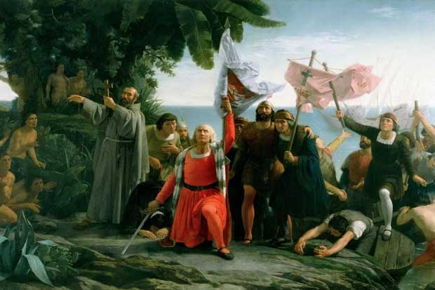
But it so happened that Columbus discovered America.
And you will immediately ask: “Why then is America called “America” and not Colombia?! Where is the copyright!” I answer immediately: there are persistent rumors that a certain Amerigo Vespucci, one of the clerks of the house of Medici (who provided money for voyages across the oceans), discovered the continent of the New World a year and a half before Columbus. Everything seems to be ironclad, but unfortunately there is no evidence of this. If anyone knows, write in the comments, otherwise we haven’t figured it out with Newton yet 😉 But the country is named after Columbus - Colombia.
Other funny historical facts You can .
We also cannot forget about Ferdinand Magellan, who discovered the strait, which was later named after him. He became the first European to travel by sea from the Atlantic Ocean to the Pacific Ocean. But his most famous trip is around the world. The great Portuguese and Spanish navigator was awarded the title adelantado, translated as “pioneer,” whom the king himself directed to conquer new lands.

But not only the West participated in new discoveries, Russian expeditions were also quite important. The annexation of Siberia was of great importance at that time. It was started in 1581 by the campaign of a detachment of the well-known Cossack ataman Ermak Timofeevich. Ermak’s campaign, with the help of government approval, contributed to the annexation Western Siberia to the Russian state. Actually, from this time on, Siberia and the Far East became colonies of the Muscovite kingdom. These Europeans sailed the seas, died of scurvy and hunger..., and the Russians “without bothering” found another way.
One of the most significant was the discovery in 1648 of the strait between America and Asia, which was made by Semyon Dezhnev together with Fedot Alekseev (Popov).
Russian ambassadors played a significant role in improving maps and routes. The most famous include I.D. Khokhlov and Anisim Gribov. They participated in the description and study of routes to Central Asia.
Consequences of the Great Geographical Discoveries
Geographical discoveries led to certain world changes. Firstly, there was a “price revolution”. The value plummeted due to the influx of gold and silver, which led to an immediate rise in prices. This caused new economic problems. Second, world trade expanded significantly and began to strengthen.
This happened thanks to new products such as tobacco, coffee, cocoa, tea, rice, sugar and potatoes, which Europeans had not heard of before. Due to their inclusion in trade, the volume of trade increased greatly. Thirdly, the development of new lands and travel across the ocean contributed to the strengthening and improvement of international relations. The only thing negative consequence this was the beginning of colonization; everything else, in principle, had a positive effect on the world order.
In conclusion, I would like to say that the progress of mankind depends on many reasons, but the most important is the desire to improve living conditions. Thanks to the Great Geographical Discoveries, new lands were developed in a relatively short time, relations between peoples were established, and trade turnover was improved. The era of VGO went down in history as one of major events in the life of humanity.
Other topics on World history, and in the video tutorials you will find in
© Alexander Chudinov
Editing by Andrey Puchkov
Throughout the history of mankind, numerous geographical discoveries have occurred, but only those that were made at the end of the 15th - first half of the 16th centuries were called Great. Indeed, never before or after this historical moment have there been discoveries of such magnitude and of such enormous significance for humanity. European navigators discovered entire continents and oceans, vast unexplored lands inhabited by peoples completely unfamiliar to them. The discoveries of that time amazed the imagination and revealed European world completely new development prospects that could not even be dreamed of before.
Prerequisites for the Great Geographical Discoveries
The sailors of that era had not only a great goal, but also the means to achieve it. Progress in navigation led to the appearance in the 15th century. a new type of vessel capable of long ocean voyages. It was a caravel - a fast, maneuverable ship, the sailing equipment of which allowed it to move even in a headwind. At the same time, instruments appeared that made it possible to navigate in distant sea voyages, first of all, the astrolabe is a tool for determining geographical coordinates, latitude and longitude. European cartographers learned to make special navigation maps that made it easier to plot courses across the ocean.

The goal of the Europeans was India, which appeared to their imagination as a country with incalculable riches. India has been known in Europe since ancient times, and goods brought from there have always been in great demand. However, there were no direct connections with her. Trade was carried out through numerous intermediaries, and states located on the routes to India prevented the development of its contacts with Europe. The Turkish conquests of the late Middle Ages led to a sharp decline in trade, which was very profitable for European merchants. The countries of the East were superior to the West in terms of wealth and level of economic development at that time, so trade with them was the most profitable type entrepreneurial activity in Europe.
After Crusades, as a result of which the European population became familiar with the values of everyday oriental culture, his needs for luxury goods, other household goods and spices increased. Pepper, for example, was then literally worth its weight in gold. The need for gold itself also increased sharply, as the development of trade was accompanied by a rapid expansion of money circulation. All this prompted the search for new trade routes to the East, bypassing Turkish and Arab possessions. India was becoming magical symbol, who inspired brave sailors.
Swimming of Vasco da Gama
The Portuguese were the first to embark on the path of great discoveries. Portugal, before other states of the Iberian Peninsula, completed the Reconquista and transferred the fight against the Moors to the territory North Africa. Throughout the 15th century. Portuguese sailors in search of gold, ivory and other exotic goods moved far south along the African coast. The inspiration for these voyages was Prince Enrique, who received the honorary nickname “Navigator” for this.
In 1488, Bartolomeu Dias discovered the southern tip of Africa, called the Cape of Good Hope. After this historical discovery, the Portuguese took a direct route through Indian Ocean to the wonderland that beckoned them.
In 1497-1499. The squadron under the command of Vasco da Gama (1469-1524) made the first voyage to India and back, thus paving the most important trade route to the East, which was a long-standing dream of European sailors. In the Indian port of Calicut, the Portuguese purchased so many spices that the income from their sale was 60 times higher than the cost of organizing the expedition.

The sea route to India was discovered and charted, allowing Western European sailors to regularly make these extremely profitable voyages.
Discoveries of Christopher Columbus
Meanwhile, Spain joined the discovery process. In 1492, her troops crushed the Emirate of Granada - the last Moorish state in Europe. The triumphant completion of the Reconquista made it possible to direct the foreign policy power and energy of the Spanish state to new grandiose achievements.
The problem was that Portugal achieved recognition of its exclusive rights to the lands and sea routes discovered by its sailors. A way out of the situation was offered by advanced science of the time. The Italian scientist Paolo Toscanelli, convinced of the sphericity of the Earth, proved that you can reach India if you sail from Europe not to the east, but in the opposite direction - to the west.
Another Italian, a sailor from Genoa, Cristobal Colon, who went down in history under the Spanish name Christopher Columbus (1451-1506), developed on this basis a project for an expedition to find a western route to India. He managed to achieve his approval by the Spanish royal couple - King Ferdinand and Queen Isabella.

X. Columbus

After a multi-day voyage, on October 12, 1492, his ships reached about. San Salvador, located near the coast of America. This day is considered the date of the discovery of America, although Columbus himself was convinced that he had reached the shores of India. That is why the inhabitants of the lands he discovered began to be called Indians.

Until 1504, Columbus made three more voyages, during which he made new discoveries in the basin Caribbean Sea.
Since the descriptions of the two “Indies” discovered by the Portuguese and the Spaniards differed sharply from each other, the names East (Eastern) and West (Western) Indies were assigned to them. Gradually the Europeans came to realize that it was not easy different countries, but even different continents. At the suggestion of Amerigo Vespucci, the lands discovered in the Western Hemisphere began to be called the New World, and soon the new part of the world was named after the insightful Italian. The name West Indies was assigned only to the islands located between the shores of the North and South America. Not only India itself, but also other countries began to be called East Indies South-East Asia all the way to Japan.
Discovery of the Pacific Ocean and the first circumnavigation of the world
America, which at first did not bring much income to the Spanish crown, was seen as an annoying obstacle on the way to rich India, which stimulated further searches. Of utmost importance was the discovery of a new ocean on the other side of America.
In 1513, the Spanish conqueror Vasco Nunez de Balboa crossed the Isthmus of Panama and reached the shores of a sea unknown to Europeans, which was first called the South Sea (in contrast to the Caribbean Sea, located north of the Isthmus of Panama). Subsequently it turned out that this is an entire ocean, which we now know as the Pacific. This is what Ferdinand Magellan (1480-1521), the organizer of the first circumnavigation of the world in history, called it.

F. Magellan
A Portuguese navigator who entered Spanish service, he was convinced that if he circumnavigated America from the south, it would be possible to reach India by the western sea route. In 1519, his ships set sail, and the next year, having crossed the strait named after the leader of the expedition, they entered the open spaces Pacific Ocean. Magellan himself died in a clash with the population of one of the islands, later called the Philippine Islands. Also died during the voyage most of his crew, but 18 of the 265 crew members, led by Captain H.-S. El Cano, on the only surviving ship, completed the first voyage around the world in 1522, thus proving the existence of a single World Ocean connecting all the continents of the Earth.
The discoveries of sailors in Portugal and Spain gave rise to the problem of delimiting the possessions of these powers. In 1494, the two countries signed a treaty in the Spanish city of Tordesillas, according to which, through Atlantic Ocean, from North Pole to the South, a demarcation line was drawn. All over again open lands to the east of it they were declared the possession of Portugal, to the west - of Spain.
After 35 years, a new treaty was concluded delimiting the possessions of the two powers in the Pacific Ocean. This is how the first division of the world took place.
“The existence of such a path can be proven based on the spherical shape of the Earth.” It is necessary to “start sailing continuously to the west”, “in order to reach places where all kinds of spices and gems. Do not be surprised that I call the country where spices grow west, while they are usually called east, because people who constantly sail to the west reach these countries by sailing on the other side of the globe.”
“The Latins should seek this country not only because great treasures, gold, silver and all kinds of precious stones and spices can be obtained from there, but also for the sake of its learned people, philosophers and skilled astrologers, and also in order to find out how how such a vast and populous country is governed and how they conduct their wars.”
References:
V.V. Noskov, T.P. Andreevskaya / History from the end of the 15th to the end of the 18th century
During travels and expeditions, new, previously unknown objects are sometimes discovered. geographical features- mountain ranges, peaks, rivers, glaciers, islands, bays, straits, sea currents, deep depressions or hills on the seabed, etc. These are geographical discoveries.
In ancient times and the Middle Ages, geographical discoveries were usually made by peoples who were most economically developed countries. These countries included Ancient Egypt, Phenicia, later - Portugal, Spain, Holland, England, France. In the XVII–XIX centuries. many of the largest geographical discoveries were made by Russian explorers in Siberia and Far East, seafarers in the Pacific Ocean, the Arctic and Antarctic.
Especially of great importance discoveries were made in the 15th–18th centuries, when feudalism was replaced by a new social formation - capitalism. At this time, America, the sea route around Africa to India and Indochina, Australia, and the strait separating Asia and the North were discovered. America (Bering), many islands in the Pacific Ocean, the northern coast of Siberia, sea currents in the Atlantic and Pacific oceans. This was the era of great geographical discoveries.
Geographical discoveries have always been made under the influence economic factors, in pursuit of unknown lands, new markets. During these centuries, powerful maritime capitalist powers emerged, enriching themselves through the seizure of discovered lands, enslavement and robbery of the local population. The Age of Discovery in the economic sense is called the era of primitive accumulation of capital.
The actual course of geographical discoveries in its most important stages developed in the following sequence.
In the Old World (Europe, Africa, Asia), many discoveries were made in ancient times by the Egyptians, Phoenicians, and Greeks (for example, during the military campaigns of Alexander the Great in Central Asia and India). Based on the information accumulated at that time, the ancient Greek scientist Claudius Ptolemy in the 2nd century. compiled a map of the world that covered the entire Old World, although far from accurate.
Significant contribution to geographical discoveries on the east coast of Africa and in South and Central Asia made by Arab travelers and merchants of the 8th–14th centuries.
In search of sea routes to India in the 15th century. Portuguese sailors circumnavigated Africa from the south, discovering the entire western and southern coast of the continent.
Having embarked on a voyage in search of a route to India across the Atlantic Ocean, the Spanish expedition of Christopher Columbus reached the Bahamas, Greater and Lesser Antilles in 1492, marking the beginning of the discoveries of the Spanish conquerors.
In 1519–1522 The Spanish expedition of Ferdinand Magellan and El Cano for the first time circumnavigated the Earth from east to west and discovered the Pacific Ocean for Europeans (it had been known to the local residents of Indo-China and South America since ancient times).
Great discoveries in the Arctic were made by Russian and foreign sailors in the 15th–17th centuries. The British explored the coast of Greenland from 1576 to 1631 and discovered Baffin Island. Russian sailors in the 16th century. already hunted sea animals near Novaya Zemlya at the beginning of the 17th century. walked along the northern coast of Siberia, discovered the Yamal, Taimyr, and Chukotka peninsulas. S. Dezhnev in 1648 passed through the Bering Strait from the Northern Arctic Ocean in Quiet.
IN southern hemisphere in the 17th century The Dutchman A. Tasman discovered the island of Tasmania, and in the 18th century. Englishman J. Cook - New Zealand and the east coast of Australia. Cook's voyages laid the foundations of knowledge about the distribution of water and land on Earth, completing the discovery of the Pacific Ocean.
In the 18th century and the beginning of the 19th century. expeditions were already organized for special scientific purposes.
TO early XIX V. Only the Arctic and Antarctic remained unexplored. The largest of the expeditions in the 18th century. was equipped by the Russian government. These are the First (1725–1728) and the Second (1733–1743) Kamchatka expeditions, when the northern tip of Asia was discovered - Cape Chelyuskin and many other objects in the North. On this expedition, V. Bering and A. I. Chirikov discovered North-West America and the Aleutian Islands. Many islands in the Pacific Ocean were discovered by Russian expeditions around the world, starting from sailing in 1803–1807. I. F. Krusenstern and Yu. F. Lisyansky. The last continent, Antarctica, was discovered in 1820 by F. F. Bellingshausen and M. P. Lazarev.
In the 19th century "white spots" disappeared with internal parts continents, especially Asia. The expeditions of P. P. Semenov-Tyan-Shansky and especially Ya. M. Przhevalsky for the first time explored in detail the vast regions of Central Asia and northern Tibet, almost unknown until that time.
D. Livingston and R. Stanley traveled to Africa.
The Arctic and Antarctic remained unexplored. At the end of the 19th century. New islands and archipelagos were discovered in the Arctic, and individual sections of the coast were discovered in Antarctica. The American R. Peary reached the North Pole in 1909, and the Norwegian R. Amundsen reached the South Pole in 1911. In the 20th century The most significant territorial discoveries were made in Antarctica and maps of its supraglacial and subglacial relief were created.
Exploring Antarctica by airplane in 1928–1930. conducted by the American J. Wilkins, then the Englishman L. Ellsworth. In 1928–1930 and in subsequent years, an American expedition led by R. Byrd worked in Antarctica.
Large Soviet complex expeditions began to study Antarctica in connection with the 1957–1959 expeditions. International Geophysical Year. At the same time, a special Soviet scientific station was established - "Mirny", the first inland station at an altitude of 2700 m - "Pionerskaya", then - "Vostok", "Komsomolskaya" and others.
The scope of the expeditions' work continued to expand. The structure and nature of the ice cover were studied, temperature regime, structure and composition of the atmosphere, movement air masses. But Soviet scientists made the most significant discoveries during their examination coastline mainland. The bizarre outlines of more than 200 previously unknown islands, bays, capes and mountain ranges appeared on the map.
In our time, significant territorial discoveries on land are impossible. The search is on in the oceans. IN last years research was carried out so intensively, and even using the latest technology, that much has already been discovered and plotted on maps that have been published in the form of an atlas of the World Ocean and individual oceans.
Now even at the bottom of the oceans there are few “white spots” left, huge deep-sea plains and trenches, and vast mountain systems have been discovered.
Does all this mean that geographical discoveries are impossible in our time, that “everything has already been discovered”? Not at all. And they are still possible in many areas, especially the World Ocean, in the polar regions, in the highlands. But in our time, the very meaning of the concept of “geographical discovery” has changed in many ways. Geographical science now sets the task of identifying relationships in nature and the economy, establishing geographical laws and patterns (see Geography).
Many important geographical discoveries date back to the last centuries of the feudal period, mainly the Renaissance. In 982 by an Icelandic Viking Eiriko Rowdy(Red) discovered Greenland, on the coast of which he developed a settlement. Eirik's son Leif Erikson, nicknamed the Happy One, apparently reached the shore in 1001 (was washed up by a storm) North America at 40 degrees N. sh., i.e. in the area of modern Philadelphia.
Late 15th century and the beginning of the 16th century. were marked by geographical discoveries made by famous navigators Columbus, Magellan, Amerigo Vespucci, Vasco da Gama and others.
Christopher Columbus(1452-1506) was born in Genoa. Also in adolescence he determined the goal of his life: to pave the shortest (as he thought) route from Europe to India, moving not as usual, to the east, but to the west. Columbus knew, of course, that the Earth was spherical. In 1485, he settled in Castile, which by that time had just been included in Spain, and obtained consent to equip a naval expedition. In total, Columbus managed to conduct four expeditions.
The first expedition dates back to 1492-1493, 4 ships and about 90 people took part in it. Columbus's ships sailed from Cape Palos (near the city of Carhatena) on August 3, 1492, and after more than two months of sailing they found themselves near the coast of Central America. During his first voyage, Columbus failed to reach the American mainland. His expedition discovered the island of San Salvador and a number of other islands of the Bahamas archipelago, the islands of Cuba and Haiti. October 12, 1492 - the day of the discovery of the island of San Salvador and the landing on its shores - is considered the official date of the discovery of America. On March 15, 1493, the ships returned to Europe.
The second expedition, consisting of 17 ships and 1.5 thousand people, took place in 1493-1496. Its participants again failed to set foot on the American mainland. The islands of Dominica and Guadeloupe, a number of other islands of the Lesser Antilles archipelago, the Jardines de la Feina archipelago, the islands of Puerto Rico, Jamaica, and Pinos were discovered. Columbus undertook aggressive campaigns deep into the island of Haiti and returned to Spain on June 11, 1496.
The third expedition (1498-1500), consisting of 6 ships, was marked by the fact that the coast of South America was reached in the area of the Orinoco River delta (the territory of modern Venezuela). The islands of Trinidad and Margarita were also discovered.
The fourth and last expedition took place in 1502-1504, 4 ships took part in it. Columbus still sought to find western path to India. The shores of Central America (the territory of modern Honduras, Nicaragua, Costa Rica and Panama) were reached, and the island of Martinique was discovered.
Columbus's discoveries were used to create Spanish colonies in new lands. The local population, called Indians by Columbus, was subjected to merciless destruction. This was the first consequence of Columbus's great geographical discoveries.
The name of the new part of the world - America - comes, as is known, from the name of the navigator Amerigo Vespucci(approx. 1451-1512) - a contemporary of Columbus, a native of Florence. In 1499 - 1504, i.e. During Columbus's third and fourth voyages, he participated in several Spanish and Portuguese expeditions to the South American region. His letters about these travels, addressed to the Italian poet, the ruler of Florence Lorenzo Medici and a certain Piero Soderini, were reprinted several times, and became very widely known. Amerigo Vespucci suggested the discovery of a new continent and called it the New World. In 1507, the Lorraine cartographer Waldseemüller named this continent America in honor of Amerigo Vespucci. The name gained recognition and was later extended to North America.
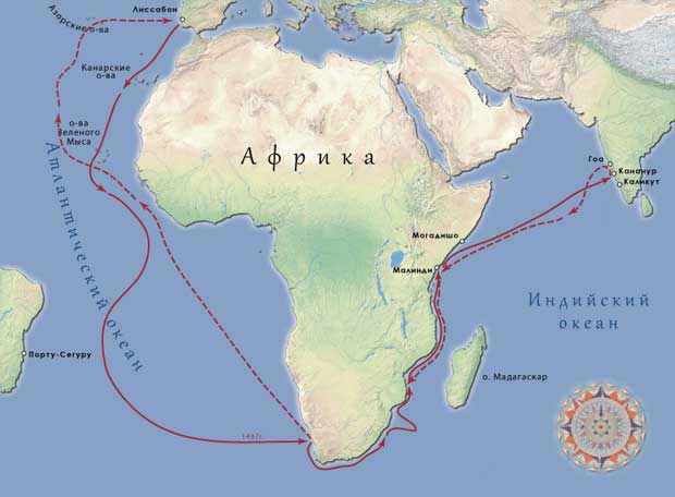
Portuguese navigator Vasco da Gama(1469-1524) first paved the sea route from Europe to the countries of South Asia. He, unfortunately, is also known for his cruelty and robberies of the population of the countries he conquered.
In 1497, an expedition of 4 ships under the command of Vasco da Gama set sail from Lisbon to India. The ships rounded the Cape of Good Hope, stopped at the Somali port of Molindi, where they took on board the Arab sailor Ahmed ibn Majid, who knew the Indian Ocean, and reached the city of Calicut (now called Kozhikode) on the coast of South India. In 1499 the expedition returned to Lisbon.
During the second expedition (1500-1502), which already included 20 ships, support bases were formed on the coast of India, north of the city of Calicut, the city of Calicut was captured, plundered and destroyed. For these “merits” in 1524, Vasco da Gama was appointed Viceroy of India. During the third expedition he died.
Ferdinand Magellan(approx. 1480-1521) - Portuguese and Spanish navigator, whose expedition first circumnavigated the world, made important geographical discoveries, showed that between Asia and America is located the largest ocean on Earth, which she called the Pacific.
Magellan's expedition, consisting of 5 ships, set off from the Spanish port of Sanluccar de Barrameda (in southern Spain) in September 1519 and reached La Plata Bay on the coast of South America in January 1520 (Buenos Aires is located in this bay ). The voyage was accompanied by great difficulties; there was no agreement between the Portuguese and Spanish sailors who were part of the expedition. From there the ships moved south along the eastern coast of South America. Their eyes met a vast unknown land - a vast plateau, which they called Patagonia.
After wintering in San Julian Bay (in the southern part of the Atlantic coast of South America), the expedition, which already included 4 ships, moved further south. The expedition managed to make an important geographical discovery - to discover a strait connecting two oceans (the Atlantic and the Great, or Pacific), located between the southern end of the South American continent and the Tierra del Fuego archipelago, which was later called the Strait of Magellan.
Having passed through it, Magellan's expedition, which consisted of only three ships, entered the ocean called the Pacific, and after a four-month voyage full of hardships (there was not enough food and fresh water) the voyage reached the Philippine Islands, which turned out to be fatal for Magellan - here he was killed in fight with local residents.
The trip around the world was completed by only one ship from Magellan's expedition - the Victoria, led by Captain Elcano, who became the head of the expedition after Magellan's death. Victoria crossed the Indian Ocean, rounded the Cape of Good Hope, entered the Mediterranean Sea and returned to the port of Sanluccar de Barrameda. Of the 265 original participants in Magellan's expedition, only 18 returned.
Magellan's expedition, in addition to geographical discoveries, the most important of which were mentioned, convincingly confirmed that the Earth has the shape of a ball, proved that most of the Earth's surface is covered with water of oceans and seas, which together make up a single world ocean.
Age of Great Geographical Discovery - the most important stage in the history of mankind. This is a time when the outlines of continents, seas and oceans become more accurate, technical instruments are improved, and the leading countries of that time send sailors in search of new rich lands. In this lesson you will learn about the sea expeditions of Vasco da Gama, Christopher Columbus and Ferdinand Magellan, as well as their discovery of new lands.
Background
Among the reasons for the Great Geographical Discoveries are:
Economic
After the era of the Crusades, Europeans developed strong trade ties with the East. In the East, Europeans bought spices, fabrics, and jewelry. In the 15th century The land caravan routes along which Europeans traded with eastern countries were captured by the Turks. The task of finding a sea route to India arose.
Technological
The compass and astrolabe (an instrument for measuring latitude and longitude) were improved.
New types of ships appeared - caravel, karakka and galleon. They were distinguished by their spaciousness and powerful sailing equipment.
Navigation charts were invented - portolans.
Now Europeans could not only make traditional coastal voyages (i.e., mainly along the coast), but also go far into the open sea.
Events
1445- an expedition organized by Henry the Navigator reached Cape Verde (the western point of Africa). The island of Madeira was discovered Canary Islands, part of the Azores Islands.
1453- Constantinople is captured by the Turks.
1471- The Portuguese reached the equator for the first time.
1488- Bartolomeu Dias' expedition reached the southernmost point of Africa - the Cape of Good Hope.
1492- Christopher Columbus discovered the islands of San Salvador, Haiti, Cuba in the Caribbean Sea.
1497-1499- Vasco da Gama reached the Indian port of Calicut, circumnavigating Africa. For the first time, the route to the East through the Indian Ocean was opened.
1519- Ferdinand Magellan sets off on an expedition in which he discovers the Pacific Ocean. And in 1521 it reaches the Mariana and Philippine Islands.
Participants

Rice. 2. Astrolabe ()

Rice. 3. Caravel ()
Successes have also been achieved in cartography. European cartographers began to draw maps with more accurate outlines of the coasts of Europe, Asia and North America. The Portuguese invented navigational maps. In addition to the outlines of the shores, they depicted settlements, obstacles encountered along the way, as well as the location of the ports. These navigation charts were called portolans.
The discoverers became Spaniards and Portuguese. The idea of conquering Africa was born in Portugal. However, the knightly cavalry turned out to be helpless in the sands. Portuguese prince Henry the Navigator(Fig. 4) decided to try the sea route along west coast Africa. The expeditions he organized discovered the island of Madeira, part of the Azores, and the Canary Islands. In 1445, the Portuguese reached the western point of Africa - Cape Verde.. Somewhat later, the coast of the Gulf of Guinea was discovered. It was discovered there a large number of gold, ivory. This is where the name came from - Gold Coast, Coast Ivory. At the same time, African slaves were discovered, which were traded by local leaders. Portugal became the first European country, which began to sell live goods.

Rice. 4. Henry the Navigator ()
After the death of Henry the Navigator, the Portuguese reached the equator in 1471. In 1488, an expedition Bartolomeu Dias reached the southern tip of Africa - Cape of Good Hope. Having circumnavigated Africa, this expedition entered the Indian Ocean. However, due to a rebellion among the sailors, Bartolomeu Dias was forced to return. His path continued Vasco da Gama (Fig. 5), which in 1497-1499. circumnavigated Africa and after an 8-month voyage arrived at the Indian port of Calicut (Fig. 6).

Rice. 5. Vasco da Gama ()

Rice. 6. Opening of the sea route to India, Vasco da Gama’s route ()
Simultaneously with Portugal, the search for a new sea route to India began Spain, which at that time was ruled Isabella of Castile and Ferdinand of Aragon. Christopher Columbus(Fig. 7) suggested new plan- reach India, moving west across the Atlantic Ocean. Christopher Columbus shared the view that the earth was spherical. On August 3, 1492, Columbus set out from Spain on three caravels “Santa Maria”, “Nina” and “Pinta” in search of India (Fig. 8). On October 12, 1492, a shot was heard on the Pinta caravel. This was the signal: the sailors had reached the island they named San Salvador, which translated means “holy savior.” After exploring the island, they went south and discovered two more islands: Haiti (then Hispaniola) and the island of Cuba.

Rice. 7. Christopher Columbus ()

Rice. 8. Route of Christopher Columbus ()
Columbus's first expedition lasted 225 days and discovered Caribbean Sea. During the next three expeditions, Columbus discovered the coast of Central America and the northern coast of South America. However, the Spanish crown was not satisfied with the amount of gold that came into the country. Soon they turned away from Columbus. He died in 1506 in poverty, confident that he had discovered a new sea route to India. Mainland, discovered by Columbus, originally called West Indies(Western India). Only later was the name given to the continent America.
The rivalry between Spain and Portugal led to the first division of the world in history. IN 1494 year was concluded Treaty of Tordesillas, according to which a conventional meridian was drawn along the Atlantic Ocean somewhat west of the Azores Islands. All newly discovered lands and seas to the west of it were to belong to Spain, and to the east - to Portugal. However first in the world trip around the world Ferdinand Magellan corrected this document.
Back in 1513, the Spaniard Vasco de Balboa crossed the Isthmus of Panama and reached the shores of the Pacific Ocean. He called him then South Sea. In the autumn of 1519, on five caravels with a crew of 253 sailors, Ferdinand Magellan (Fig. 9) set off on his journey (Fig. 10). His goal was to find a route across the Atlantic Ocean to the Moluccas (spice islands). After a year of travel, Magellan's team entered a narrow strait, which was later named Strait of Magellan. Having passed through it, Magellan's team managed to enter the previously unknown ocean. This ocean was named Quiet.

Rice. 9. Ferdinand Magellan ()

Rice. 10. Ferdinand Magellan's first trip around the world ()
In March 1521, Magellan's team reached the Mariana Islands and then landed in the Philippines, where Magellan himself died in a skirmish with local residents. His team managed to reach the Moluccas. Three years later, only one ship with 17 sailors returned home. Magellan's first trip around the world proved that the Earth is spherical..
European exploration of the New World took the form conquests - conquests. Along with the conquest, the resettlement of colonists from Europe to the New World began.
Great geographical discoveries changed the picture of the world. First, it was proven that the Earth is spherical. A new continent was also discovered - America, as well as a new ocean - the Pacific. The outlines of many continents, seas and oceans were clarified. Great geographical discoveries were the first step towards the creation of a world market. They shifted trade routes. So, trading cities Venice and Genoa lost their key importance in European trade. Their place was taken by ocean ports: Lisbon, London, Antwerp, Amsterdam, Seville. Due to the influx of precious metals into Europe from the New World, a price revolution occurred. Prices for precious metals fell, while prices for food and raw materials for production increased.
Great geographical discoveries marked the beginning of the colonial redistribution of the world and the dominance of Europeans in Asia, Africa and America. The exploitation of slave labor and trade with the colonies allowed European trading circles to enrich themselves, which became one of the prerequisites for the formation of capitalism. Also, the colonization of America led to the destruction of ancient American cultures. Great geographical discoveries became one of the reasons for the food revolution in Europe. Previously unknown crops were introduced: corn, tomatoes, cocoa beans, potatoes and tobacco.
Bibliography
- Boytsov, M.A. Magellan's Path: Early Modern Times. History reading book. - M., 2006.
- Vedyushkin V.A., Burin S.N. Textbook on the history of modern times, grade 7. - M., 2013.
- Verlinden Ch., Mathis G. “Conquerors of America. Columbus, Cortes." Rostov-on-Don: Phoenix, 1997.
- Lange P.V. Like the sun... The life of Ferdinand Magellan and the first circumnavigation of the world. - M.: Progress, 1988. ; Artist
- What discovery was Ferdinand Magellan famous for, and what continent did Christopher Columbus discover?
- Do you know any other famous navigators and the territories they discovered?
